Travel, Atlases, Maps and Natural History
Travel, Atlases, Maps and Natural History

MacDonald Gill | Two wartime maps: Australia, 1942, and New Zealand, 1943
Lot Closed
May 13, 01:48 PM GMT
Estimate
700 - 1,000 GBP
Lot Details
Description
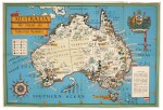
MacDonald Gill
Two maps: Australia, 1942, and New Zealand, 1943, comprising:
Australia. Her Natural and Industrial Resources, 1942, printed by Alf Cooke Ltd., colour lithographed map (500 x 740mm.), decorative coat-of-arms in upper right corner, large compass rose in the lower left, a few small holes and tears, slight wear along folds, dust-staining on the reverse
New Zealand. Her Natural and Industrial Resources, 1943, printed by Fosh & Cross Ltd, colour lithographed map (510 x 760mm.), decorative coat-of-arms in upper right corner, compass rose in the lower right, slight wear along folds, dust-staining on the reverse
During the Second World War, MacDonald Gill was commissioned by the British Ministry of Information to design colourful pictorial maps showing natural resources of Commonwealth countries to illustrate their economic contribution to the war effort. The map of Australia shows the natural or industrial resources of coal, platinum, copper, silver, gold, steel, iron, tin, lead and zinc. The map of New Zealand shows the natural or industrial resources of coal, oil, gold, platinum, iron, tungsten and mercury extraction.