Richard Marshall | World map, 1785
Lot Closed
May 13, 01:49 PM GMT
Estimate
4,000 - 6,000 GBP
Lot Details
Description
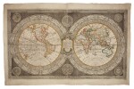
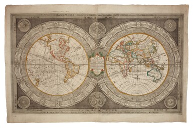
Richard Marshall
A Curious map of the world corrected from the observations communicated to ye Rl. Society of London & the Royl. Accademy at Paris. Likewise from the late voyage round ye world, performed by the Honble. Comodore Byron Captn. Cook etc. London: John, James & Eleanor Marshall, 1785
610 x 1030mm., engraved map on two sheets joined, contemporary outline colour,
A large world map with each sphere bordered with scientific facts and theories, and with astronomical diagrams in further spheres in the corners and cusps. The map itself is notable for showing both Hawaii and the Bering Strait, resulting from Captain Cook's third voyage (1776-1769), yet still depicting California as an island.
The map was originally issued circa 1770 by Richard Marshall, a printer known for re-issuing Christopher Saxton's Elizabethan county maps in partnership with Cluer Dicey. This example is dated two years after Richard's death, when his widow Eleanor and two sons, James and John, ran the business.
LITERATURE:
Cf. Armitage, The World at their fingertips: Eighteenth-century British two-sheet double-hemisphere world maps, 19 (first state)
You May Also Like


![(Hamilton, Alexander, James Madison, and John Jay) | Bushrod Washington's Federalist, praised by George Washington as a "work [that] will merit the notice of Posterity"](https://dam.sothebys.com/dam/image/lot/8ec02b17-38b4-4269-8039-d4830cd55431/primary/extra_small)


![[World War II – 21st Army Group] | An important archive of maps and files documenting the allied campaign in Europe, from the early stages of planning for D-Day and Operation Overlord, to the German surrender](https://dam.sothebys.com/dam/image/lot/f958941f-80a5-4c71-935b-c5441da85aa9/primary/extra_small)


