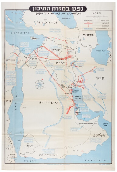
Arabia—Israel Defence Forces | Neft ba-mizrah ha-tikhon (Oil in the Middle East), folding map, 1957
Lot Closed
November 17, 02:38 PM GMT
Estimate
2,000 - 3,000 GBP
Lot Details
Description
Arabia—[Israel Defence Forces]
Neft ba-mizrah ha-tikhon. Zikaynot, shadot, tzinorot, batei zikuk. (Oil in the Middle East. Concessions, Oilfields, Pipelines, Refineries). Tel Aviv, 1957
(82.2 x 56.0cm.), folding chromolithographed map of the Arabian Peninsula including Turkey, Saudi Arabia, Egypt, Israel, Palestine, Jordan, Syria, Lebanon, Iraq, Iran, Kuwait, Bahrain, Qatar, United Arab Emirates, Oman, and North and South Yemen, to the scale of 1:5,000,000, scale and key in Hebrew inset to top-right, inset explanatory panels in Hebrew and English, compass rose in Saudi Arabia, foxing along creases, hole and tear at crease points
RARE Israeli strategic map of the Arabian peninsula showing oilfields and associated infrastructure.
Printed in black, red, and blue, the map demarcates the political boundaries of the time along with the areas covered by oil companies' concessions. Pipelines form a web across the northern part of the Arabian Peninsula, while oil fields and refineries, large and small, are also marked. The map was most probably created by the IDF in reaction to the Suez Crisis, and its associated geopolitical shifts. With the Egyptians operating the Suez Canal, and Britain and France being forced by the USA to abandon their post-imperial plans, Israel now counted in both US and Soviet plans for their control of Middle Eastern politics. Britain was forced to anchor its Middle Eastern influence in Cyprus, Aden and Iraq, while the increased American influence can be seen in the huge swathe of territory assigned to the Arabian-American Oil Company (Aramco).
You May Also Like