
Henri Abraham Chatelain | Atlas historique, Amsterdam, 1739, 7 volumes, half calf over marbled boards
Lot Closed
July 11, 11:05 AM GMT
Estimate
10,000 - 15,000 GBP
Lot Details
Description
Henri Abraham Chatelain
Atlas historique. Amsterdam: Châtelain, 1720-1739
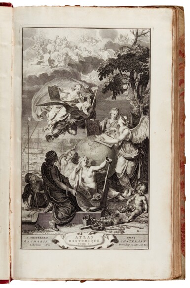
7 volumes, folio (490 x 290mm.), half titles, 6 allegorical frontispieces (in volumes 1-5 and 7: 1 and 7 by B. Picard dated 1720, with note on the new edition and note of the historical atlas, volumes 2-4 after Rom. de Hooge and by Sluyter, and volumes 5-6 by and after B. Picard dated 1719), all volumes with title with engraved printer's device, preface with illuminated initials and decorative bands, and table of contents, volume 6 lacking frontispiece
Volume 1: 1739, 45 plates, many folding, depicting maps, genealogies, tables and other illustrations, of the ancient world, and contemporary Italy, France and Spain;
Volume 2: 1720, 38 plates, many folding, depicting maps, genealogies, tables and other illustrations, of ancient Rome and the inheritance of the Roman Empire;
Volume 3: 1738, 34 plates, depicting maps, genealogies, tables and other illustrations, of England, Scotland, Ireland, the Swiss territories, Savoy, Lorraine and Venice, with geographical and genealogical tables for the second volume;
Volume 4: 1735, 34 plates, depicting maps, genealogies, tables and other illustrations, of the Scandinavian and Baltic lands, Poland, Muscovy, Turkey and the Near East;
Volume 5: 1732, 58 plates, depicting maps, genealogies, tables and other illustrations, of Asia, including the Babylonian and Greek empires, Armenia, Georgia, Turkey and the Holy Land, Persia, Tartary, the Mogul Empire, and China, Japan and Siam, with a dedicatory epistle to Eugene François of Savoy and Piedmont;
Volume 6: 1732, 39 plates, depicting maps, genealogies, tables and other illustrations, of Africa, South, Central and North America, and the Pacific, lacking frontispiece and half-title, lacking the double-page map “Carte tres curieuse de la Mer du Sud”, endpapers detaching;
Volume 7: 1720, supplement with 44 plates, depicting maps, genealogies, tables and other illustrations, addressing chronology, the Occident and the Orient, heraldry, the regions and ruling powers of France, Austria, Italy, Spain and Portugal, military history, religion and mythology, with a dedicatory epistle to Jean Antoine Schafgotsch;
contemporary pink half calf over marbled boards, spines with raised bands in 8 compartments gilt, UNCUT, scattered foxing and staining, some edges slightly frayed, corners bumped, covers stained, rubbed
Henri Abraham Chatelain (1648-1743) was a Dutch cartographer. His Atlas Historique was one of the most expansive encyclopedias of the age, covering not only geography, but global history, politics and genealogy. The maps were engraved by Chatelain himself. It was initially published in Amsterdam between 1705 and 1721, and subsequently by Chatelain between 1732-1739, making this collection of the seven volumes a combination of the two printings. Volume 6 features particularly fine maps of the Americas.
Sold not subject to return.
LITERATURE:
Koeman II, ch. 1-7; Phillips, Atlases, 579; Goffart, Historical Atlases, p. 134
PROVENANCE:
E.G. Sarsin, bookplate
You May Also Like


![(Hamilton, Alexander, James Madison, and John Jay) | Bushrod Washington's Federalist, praised by George Washington as a "work [that] will merit the notice of Posterity"](https://dam.sothebys.com/dam/image/lot/8ec02b17-38b4-4269-8039-d4830cd55431/primary/extra_small)


![[World War II – 21st Army Group] | An important archive of maps and files documenting the allied campaign in Europe, from the early stages of planning for D-Day and Operation Overlord, to the German surrender](https://dam.sothebys.com/dam/image/lot/f958941f-80a5-4c71-935b-c5441da85aa9/primary/extra_small)


