
Jefferys, Thomas | A cartographical record of emerging colonial interests in the West Indies
Auction Closed
April 26, 08:00 PM GMT
Estimate
7,000 - 10,000 USD
Lot Details
Description
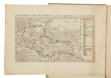
Jefferys, Thomas
A Description of the Spanish Islands and Settlements on the Coast of the West Indies… London: T. Jefferys, 1762
4to (275 x 210 mm). 32 folding engraved maps by Jefferys, the frontispiece map hand-colored in outline; some foxing primarily to text leaves, some marginal browning, D2-D3 loose but holding, map facing pg. 20 numbered as 5 rather than 6, closed primarily marginal tear to folding map facing pg. 73, small tear or paper flaw to inner margin of M3. Early paper-covered boards; rubbed, vertical cracks to spine with some loss, joints weak. Housed in custom box.
First edition. The present work was published at a crucial time for colonial interests in the West Indies. Hostilities between Britain, France, and Spain had ceased with Britain temporarily in possession of most of the French islands. Despite fierce lobbying from West Indian planters, the major islands of Guadeloupe and Martinique were returned to France as part of the trade-off by which France agreed to quit Canada.
REFERENCE:
Palau 123372; Phillips 3941; Sabin 35959
You May Also Like


![(Hamilton, Alexander, James Madison, and John Jay) | Bushrod Washington's Federalist, praised by George Washington as a "work [that] will merit the notice of Posterity"](https://dam.sothebys.com/dam/image/lot/8ec02b17-38b4-4269-8039-d4830cd55431/primary/extra_small)
![[World War II – 21st Army Group] | An important archive of maps and files documenting the allied campaign in Europe, from the early stages of planning for D-Day and Operation Overlord, to the German surrender](https://dam.sothebys.com/dam/image/lot/f958941f-80a5-4c71-935b-c5441da85aa9/primary/extra_small)


