Travel, Atlases, Maps & Natural History
Travel, Atlases, Maps & Natural History
Abraham Ortelius | Théâtre de l'Univers, Antwerp, 1587, extra-illustrated with 11 maps by Jaillot, Frieux and Danckerts
Lot Closed
November 15, 01:46 PM GMT
Estimate
30,000 - 40,000 GBP
Lot Details
Description
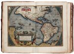
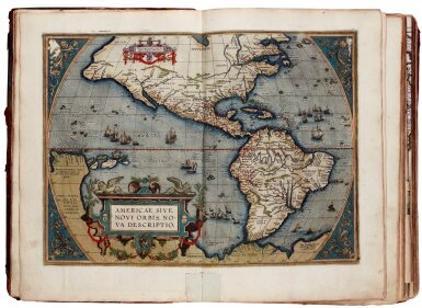
Abraham Ortelius
Théâtre de l'Univers. Antwerp: Christoffel Plantin, 1587
2 parts in one volume, folio (440 x 295mm.), text in French, 112 double-page engraved maps, all finely hand-coloured by a contemporary hand, EXTRA-ILLUSTRATED with 11 engraved folding maps and views (c.1690-c.1703), mostly hand-coloured, by Jaillot, Frieux and Danckerts, eighteenth-century ownership inscription to front free endpaper, eighteenth-century calf, lacking engraved title and "Privilege" leaf (A6r) at end of Paregon, minor adhesive residue at edges of world map, tear at join of world map, many of the extra-illustrated maps defective with tears including the map of Asia, and marginal repair to map of the Americas, final gathering becoming detached, some creases and tears to folding maps from c.1690s, lacking spine (but with fragments preserved in prelims), rubbed
The Theatrum is widely recognised as the first modern atlas, which came to shape the future of cartography. "Shape and contents set the standards for later atlases, when the centre of the map-trade moved from Antwerp to Amsterdam. The characteristic feature of the Theatrum is, that it consists of two elements, forming part of a unitary whole: text and maps. This concept for a 'Theatre of the world' was followed through the 17th century. Before Ortelius no one had done this" (Koeman).
The two parts comprise: Théâtre, dedication "Av Prvdent Senat", address to the reader leaves, frontispiece explication poem, poem addressed "Av Debonaire Spectatevr et Lecteur du Theatre" with hand-coloured engraved portrait of Ortelius on verso, 100 double-page mapsheets + 8 additional folding maps from c.1690s; Paregon, letterpress title in ornamental frame, 12 mapsheets, "L'Adiev De L'Avctevr Av Lectevr", "Voyes, Chemins Et Addresses...", "Noms D'Avcvnes Marchandises Estranges...", "La Table, ou Indice des Tiltres des Cartes...", "Povrce Qv'En Ces Cartes...".
The 11 additional folding maps and views bound into the volume include: map of Europe by H. Jaillot; map of Asia by Jaillot (dated 1694); map of Africa by Jaillot (dated 1694), map of Geldria and Zutphania by Justinius Danckerts; "Holsatiae Tabula Generalis" (map of the Hamburg region); large folding engraved view of Naples; woodcut illustrations showing European military fortifications.
LITERATURE:
Koeman 31:331
PROVENANCE:
Madame Marie Courtens, eighteenth-century signature