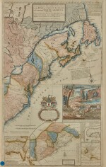
Herman Mill, a handcolored copy of the celebrated Beaver map
Lot Closed
January 21, 03:33 PM GMT
Estimate
7,000 - 9,000 USD
Lot Details
Description
Herman Moll
A New and Exact Map of the Dominions of the King of Great Britain on ye Continent of North America, containing Newfoundland, New Scotland, New England, New York, New Jersey, Pensilvania, Maryland, Virginia and Carolina. [London] Printed and sold by T. Bowles, J. Bowles, and I. King, 1715 [i.e. 1731]
Engraved map of North America on two joined sheets (totaling 40 1/2 x 25 1/2 in.). Colored by hand, inset maps of "the Improved Part of Carolina," "the South Part of Carolina, and the East Part of Florida," "ye Town and Harbour of Charles-Town," and "the Principal Part of North America," large inset vignette of "ye Industry of ye Beavers of Canada," armorial dedicatory cartouche to Walter Dowglass; some light surface soilings, a few closed marginal tears and repairs. Handsomely framed.
Popularly dubbed the "Beaver map" because of its striking inset of Niagara Falls with a colony of industrious beavers building a dam, Moll's celebrated map counts among the earliest and most important cartographic documents relating to the ongoing boundary disputes in North America between France and Great Britain. "The map was the primary cartographic exponent of the British position during the period immediately following the Treaty of Utrecht in 1713" (Degrees of Latitude, p. 114).
The beaver perfectly conveyed the spirit of North America: the animal was key to the fur trade and its industrious nature symbolized that those who were productive would control the land and garner wealth and prosperity. Moll borrowed the scene from Guerard's decorative vignette which first appeared in the "original" beaver map, Nicolas de Fer's monumental wall map of America, published in 1698; but it is Moll's map that remains etched in collective memory.