Fine Books and Manuscripts, Including Americana
Fine Books and Manuscripts, Including Americana

Arrowsmith, Aaron. The first edition of Arrowsmith's sweeping survey of the Caribbean
Lot Closed
October 15, 04:12 PM GMT
Estimate
8,000 - 12,000 USD
Lot Details
Description
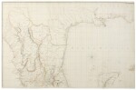
ARROWSMITH, AARON
CHART OF THE WEST INDIES AND SPANISH DOMINIONS IN NORTH AMERICA...TO ADMIRAL JOHN WILLETT PAYNE, A DISTINGUISHED NATIVE OF THE WEST INDIES...THIS CHART IS RESPECTFULLY DEDICATED BY HIS MOST OBEDIENT SERVT. A. ARROWSMITH. LONDON: PUBLISHED...BY A. ARROWSMITH NO. 24 RATHBONE PLACE, 1ST JUNE 1803
Engraved map printed on four sheets (approx: 48 x 75 in.; 1,219 x 1,905 mm if joined). period hand-coloring in outline; splits at folds expertly repaired.
The first edition of Arrowsmith's sweeping survey of the Caribbean —"this map is the largest scale and most accurate map of those areas published to date, preceding Pike's and Humboldt's maps by several years" (Rumsey).
First edition of Arrowsmith's four-sheet map of Florida, the Gulf Coast, West Indies, Mexico to the Pacific and Central America. At the time of publication, this large-scale work was the most detailed and accurate depiction of the region. Arrowsmith had access to the best available information, basing the map in part on the pre-Revolutionary War surveys of De Brahm and Bernard Romans. According to Streeter the coast line follows generally the Carta Esferica of 1799, but with the longitude of Sabine Pass nearly correct. "The 1810 second and later editions only extend to the east coast of Mexico...In its coverage of Mexico and Central America, this map is the largest scale and most accurate map of those areas published to date, preceding Pike's and Humboldt's maps by several years." (Rumsey)
Aaron Arrowsmith was the founder of one of the leading London map publishing houses in the early part of the nineteenth century. He came to London about 1770 from Durham, his birthplace, and worked as a surveyor for John Cary. In 1790 he set up his own business in Long Acre and soon established an international reputation as a specialist in compiling maps recording the latest discoveries in all parts of the world. He produced, and constantly revised, a great number of large-scale maps, many issued singly as well as in atlas form. After his death the business passed to his sons, Aaron and Samuel, and later to his nephew John who maintained his uncle's reputation, becoming a founder member of the Royal Geographical Society.
Stevens & Tree cite editions of 1803 and 1810, with Phillips adding 1811 and 1816 issues. The present first edition, dedicated to Admiral John Willett Payne, is greatly preferred as it depicts as far west as the Pacific coast of Mexico, which was removed from the later editions.
REFERENCE:
Phillips, A List of Maps of America 1061 (1811 edition); Rumsey 4121; Stevens & Tree, "Comparative Cartography" 89a, in Tooley, The Mapping of America; Streeter, Texas 1301; Tooley. "Printed Maps of America" I:185, in Map Collector's Circle VII (1971)