
Age of Wonder
Age of Wonder
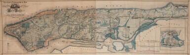
(New York) — Viele, Egbert L | "The most enduring 19th-century map of Manhattan"
Lot Closed
December 9, 08:26 PM GMT
Estimate
18,000 - 24,000 USD
Lot Details
Description
(New York) — Viele, Egbert L
Sanitary and Topographical Map of the City and Island of New York. Prepared for the Council of Hygiene & Public Health, of the Citizens Association, 1865
Lithographic map (to sight: 46.3 x 161.9 cm; framed: 59.3 x 185.1 cm). Handcolored, backed with linen; old folds, some splitting to folds with minor loss, a few stray spots, minor browning primarily to left half. Handsomely matted, glazed, and framed; not examined out of frame.
The celebrated "water map" of New York City—a striking depiction of 19th century Manhattan.
Viele's work has long served as a valuable guide to engineers and contractors for major building projects, from the Empire State Building to the United Nations (“Our bible in this case is the Viele map of 1865…”). It depicts Manhattan’s natural waterways—many now subterranean—and how they were affected by the construction of streets and buildings. Originally showing only lower Manhattan, it was published in 1859 as part of a report to the U.S. Sanitary Commission. The present enlarged map, showing the entire island, was printed separately and to accompany the 1865 Report of the Council of Hygiene and Public Health.
Viele was one of the major New York mapmakers and engineers of his day. He was named chief engineer of the Central Park project in 1856, but that of Olmsted and Vaux superseded his design. In 1860 he was appointed engineer of Prospect Park; later on he served as Commissioner of Parks. Another version of the present map appeared in 1874, completing twenty years of Viele’s study of Manhattan’s topography. He must be recognized as the ultimate authority on the subject, as his wonderful “water map” is still in use today.
As urban areas exploded in the 19th century, there was a particular focus placed on sanitation science, and the importance of clean water. In looking at Viele's map, we can think of Herman Melville's Ishmael, "growing grim about the mouth" in the "insular city of the Manhattoes, belted round by wharves as Indian isles by coral reefs—commerce surrounds it with her surf" (Melville 1; see lot 1016). And we can recall Charles Dickens's Little Dorrit (see lot 1020), which also focuses on the quality of life to be had in these burgeoning metropoles. "Through the heart of [London] a deadly sewer ebbed and flowed in the place of a fine fresh river" (Dickens 21), the novel's narrator observes. It is likely that New York learned from the error of London's ways, and the present map conveys an incredible effort to prevent the sort of rampant pollution that plagued London, and that perhaps drove Ishmael to sea.
"The most enduring 19th-century map of Manhattan" — here, handsomely presented.
REFERENCE:
Dickens, Little Dorrit (London: Bradbury and Evans, 1855-1857); Manhattan in Maps, 136-139; Melville, Moby-Dick (New York: Harper 1851)