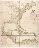

P.A.F. Tardieu | A Map of the United States and Canada / A Map of the West-Indies and the Mexican-Gulph, 1806
Lot Closed
November 17, 04:46 PM GMT
Estimate
3,000 - 4,000 GBP
Lot Details
Description
P.A.F. Tardieu
A Map of the United States and Canada, New-Scotland, New-Brunswick and New-Foundland / A Map of the West-Indies and of the Mexican-Gulph. Paris: P.A.F. Tardieu, 1806
Two maps (together 904 x 753mm.), 1:6,000,000 scale, 16 sheets, dissected and linen backed, hand coloured denoting territorial boundaries, each map with cartouche, the upper map featuring the eastern United States including Louisiana, New York, New Foundland, New Scotland, New Brunswick and the Great Lakes, the lower map featuring the Gulf of Mexico, the West Indies, Central America and the north coast of South America, decorative paper label to linen panel with title, minor dampstaining to upper left corner and along margins
These scare maps have been backed together on linen to form an impressive depiction of the eastern United States, Mexican Gulf and Caribbean Isles, hand-coloured according to the colonial territories.


