
Japan, Mount Kōya. Engraved map (1884) and large colour photograph of a manuscript map
Auction Closed
July 28, 03:29 PM GMT
Estimate
2,000 - 3,000 GBP
Lot Details
Description
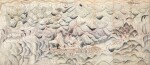
JAPAN, MOUNT KŌYA
Engraved map and large colour photograph.
Colour photograph (618 x 1427mm.)
Kōya-san Ichiran Zenzu, 高野山一覧全圖, (17th year of the Meiji Period, 1884), folding engraved map of Kōyasan, (405 x 705mm.), minor worming, a few holes or repairs to verso
Mount Kōya or Kōyasan (高野山), is a UNESCO World Heritage site and one of Japan's most revered pilgrimage sites. It has several hundreds of temples and was founded 816AD, by the famous Buddhist monk Kukai (空海) (774–835).
The specially commissioned photograph depicts the earliest known manuscript map of Mount Kōya, dated 1645, or the 2nd year of the Shōhō Period. The monumental map, also known as the Shōhō map, measures 3537 x 1520mm. "The Shōhō map illustrates for the first time in great detail the location of the existing temples of the time, the names of the villages supplying food for the monks, roads for access to the mountain the distant Kinokawa rover and Jizon-In temple, principal starting point to the mountain for pilgrims" (Lukacs).
The photograph was specially created by the Kōyasan University Library upon request by Dr G. Lukacs for his investigation of the mapping history of the site.
LITERATURE:
Lukacs, G. Mapping Mount Kōya, one of Japan's most revered pilgrimage sites (The Cartographic Journal, 2018), pp. 1-14