Books and Manuscripts: A Summer Miscellany
Books and Manuscripts: A Summer Miscellany

MALAYSIA | Reconnaissance Map South-East Pahang, 1922
Lot Closed
August 4, 01:53 PM GMT
Estimate
1,500 - 2,000 GBP
Lot Details
Description
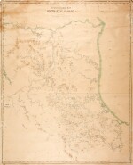
MALAYSIA.
RECONNAISSANCE MAP SOUTH-EAST PAHANG. [KUALA LUMPUR]: FEDERATED MALAY STATES SURVEY NUMBER 216, 1922
Lithographed map, 1280 x 1090mm., backed on linen, some slight loss, fraying and cracking
This highly detailed map, on a scale of two miles to the inch, is one of the earliest large-scale surveys of southeast Pahang, Malaysia. A great deal of information is shown including state boundaries marked with dot and dash lines, contours, mountain heights, tin mines, rivers, swamps, trigonometrical stations, unexplored flat land, and names of rivers, hills, and villages; these include Chini Lake, Tasek Bera, Sungei Pahang, Sungei Rompin, Sungei Endau, Sungei Merchong, among others. Two dashed parallel lines mark a proposed road to Bahau.
Set up in 1908, the Survey Department of the Federated Malay States was the government department responsible for the mapping, charting in the states of Perak, Pahang, Selangor and Negri Sembilan. In 1920 the department was amalgamated with the Straits Settlement Survey Department.
Rare; we are only able to trace four institutional examples: the British Library, Leiden University, National Archives Singapore, and The National Archives, Kew.
To view Shipping Calculator, please click here