
- 619
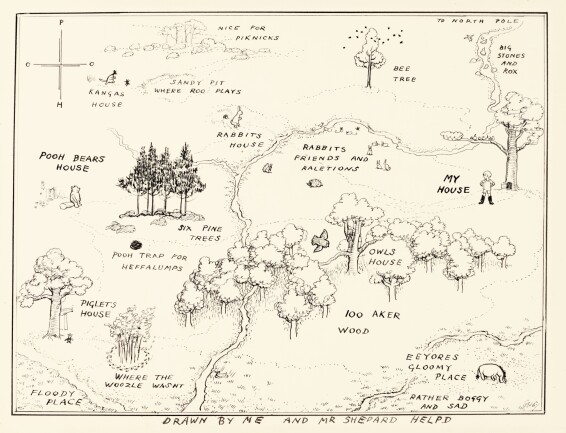
SHEPARD, THE ORIGINAL MAP OF THE HUNDRED ACRE WOOD, ORIGINAL INK DRAWING, 1926 (FRAMED AND GLAZED)
估價
100,000 - 150,000 GBP
Log in to view results
招標截止
描述
- Attributed to E.H. Shepard
- The Original Map of the Hundred Acre Wood
- ink drawing on paper
267 by 355mm. (sheet 380 by 449mm.), signed with initials "EHS" lower right, some browning below mount
來源
The Sporting Gallery, 26 November – 21 December 1926, item 2; sold in these rooms, 5 February 1968, lot 196 (“The Property of H.H. The Prince of Pudukota”); sold in these rooms, 16 March 1970, lot 372
Condition
Condition is described in the main body of the cataloguing, where appropriate.
"In response to your inquiry, we are pleased to provide you with a general report of the condition of the property described above. Since we are not professional conservators or restorers, we urge you to consult with a restorer or conservator of your choice who will be better able to provide a detailed, professional report. Prospective buyers should inspect each lot to satisfy themselves as to condition and must understand that any statement made by Sotheby's is merely a subjective, qualified opinion. Prospective buyers should also refer to any Important Notices regarding this sale, which are printed in the Sale Catalogue.
NOTWITHSTANDING THIS REPORT OR ANY DISCUSSIONS CONCERNING A LOT, ALL LOTS ARE OFFERED AND SOLD AS IS" IN ACCORDANCE WITH THE CONDITIONS OF BUSINESS PRINTED IN THE SALE CATALOGUE."
拍品資料及來源
PROBABLY THE MOST FAMOUS MAP IN ENGLISH LITERATURE. THIS ILLUSTRATION HAS BEEN IN A PRIVATE COLLECTION FOR ALMOST FIVE DECADES. Once Milne had created the literary landscape of the hundred acre wood and surrounding features, it was Shepard who firmly established the visual setting. With typical Shepard humour the map is supposed to be the work of Christopher Robin ("Drawn by me and Mr Shepard helpd") and includes a number of Christopher Robin’s own spellings ("piknicks", "raletions" and "rox").
The map was reproduced on the endpapers of Winnie-the-Pooh and, at least for Shepard, established a definite visual style. In 1931 when Shepard worked on The Wind in the Willows his first innovation was to introduce a map of the locality on the endpapers. Both maps, of course, pre-date those in Tolkien’s The Hobbit.
Just as Shepard’s map is the means of entry to the book, it is also the first animated sequence in the Disney film (Winnie the Pooh and the Honey Tree, 1966).
Shepard produced at least two preliminary drawings for the map (one in the collection of the V&A Museum and an earlier sketch sold in these rooms, 17 December 2008). This, the original as used by the publishers, was sold by Shepard in his exhibition at The Sporting Gallery, 26 November – 21 December 1926. It was given the title, in the exhibition catalogue, as simply "Map of Pooh’s Country". Below the mount Shepard has added the caption "Winnie-the-Pooh. Map for end papers". The reverse of the board also notes "Map for End Papers".