
David Burr | An atlas of the state of New York. New York 1829, a landmark in the cartography of American states
Auction Closed
November 28, 01:19 PM GMT
Estimate
5,000 - 7,000 GBP
Lot Details
Description
David Burr
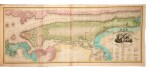
An atlas of the state of New York. New York: published by David H. Burr, 1829
FIRST EDITION folio (570 x 430mm.), engraved title with vignette “View on the Hudson River near Fishkill”, 52 hand-coloured engraved maps by Burr (nos. 2 and 3 joined to form a single folding map), 3 folding, 18 double-page, recent period-style half calf gilt over original marbled paper boards, preserved in a fine modern green morocco-backed clamshell case, a few text leaves discoloured, maps with mild offsetting
An oversized work described by Short as “a landmark document that constitutes one of the most precise cartographic records of the state”. It is also one of the earliest such records, being just the second atlas to be produced for any U.S. State, after Mills’s 1825 Atlas of South Carolina.
Burr (1803–1875) was an early and important cartographer for his young country. After attending law school, he joined the New York State Militia and was assigned to work with the state’s Surveyor General Simeon De Witt on mapping New York roads. Seeing the need for a state-wide guide, Burr approached the governor about combining the work he and De Witt had done with other surveys, and the present state atlas was the result. The New York Legislature provided funding, and Burr published the work, incorporating a map of the whole state, the “Commissioner’s Plan” map of New York City, and a map of every county.
The importance of the atlas was immediately recognised, and a second edition, issued in 1839, acknowledged that it was “regarded as the only safe depository of the original surveys of this great and growing state to which the people could have convenient access.” Burr went on to serve as official topographer of the U.S. Post Office, mapping postal routes, and as geographer to the U.S. Senate. While serving in the latter position, he produced his last known map, the 1854 “Map of the United States.”
REFERENCES: Short, Representing the Republic: Mapping the United States 1600-1900, pp.85-88; Howes B-1017; Phillips, Atlases 2206; Sabin 19873


