Travel, Atlases, Maps and Photographs
Travel, Atlases, Maps and Photographs

North and Central America | A collection of 5 maps
Lot Closed
May 24, 02:28 PM GMT
Estimate
1,000 - 1,500 GBP
Lot Details
Description
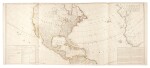
North and Central America—Abraham Ortelius and others
Collection of five maps, comprising:
i) Abraham Ortelius. Peruviae auriferae regionis (with:) La Florida; Guastecan Reg, [no date], hand-coloured
ii) Henricus Hondius. America noviter delineate, 1631, coloured in outline, slight spotting
iii) Joannes Jansson. Insulae americanae in oceano septentrionali, [no date], hand-coloured
iv) Jean Baptiste Bourguignon d'Anville. [A New Map of the Whole Continent of America (North American sheets only)]. London: Bennett and Sayer, 1794
v) Samuel Dunn. North America, as divided amongst the European powers. London: Robert Sayer, 1774, coloured in outline