Travel, Atlases, Maps and Photographs
Travel, Atlases, Maps and Photographs
Middle East | A collection of 13 maps
Lot Closed
May 24, 01:54 PM GMT
Estimate
1,500 - 2,000 GBP
Lot Details
Description
Middle East
A collection of 13 maps, comprising:
i) Braun and Hogenberg. Alexandria vetustissimum. [Cologne, late sixteenth or early seventeenth century], 405 x 520mm., double page bird’s eye view of Alexandria, three small holes
ii) Braun and Hogenberg. Cairus quae olim Babilon Aegipti maxima urbs. [Late sixteenth or early eighteenth century], 415 x 550mm., double-page engraved bird’s-eye view, browned
iii) Thomas Fuller. Desertum Paran. [London, c. 1650], 325 x 390mm., engraved map
iv) Pierre Mortier. Carte particuliere de la Mer Rouge. [Paris, c. 1700], 630 x 880mm., folding hand-coloured engraved map
v) Emanuel Bowen. An accurate map of Turky in Asia. [London, c. 1750], 200 x 255mm., engraved map
vi) Cellarius. Arabie Petraea and Deserta. [London, c. 1750], 220 x 335mm., hand-coloured engraved map
vii & vii) Palmer. Ancient Jerusalem with the land Moriah [with] The Dominions of David and Solomon. York: A. and W. Barclay, 1823, 125 x 185mm., a pair of small hand-coloured engraved maps, mounted, old tape on verso
ix) James Wyld. Lower Egypt. London, [c. 1824], 585 x 820mm., double-page engraved map, hand-coloured in outline, chipped at head
x) Henry Teesdale. Ancient Palestine. London: Teesdale, 1834, 460 x 365mm., double-page engraved map, hand-coloured in outline
xi) G.F. Cruchley. Canaan or the Land of Promise. London, 1857, 470 x 375mm., hand-coloured engraved map
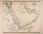
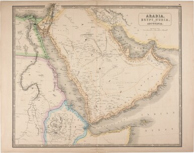
xii) George Philip & Son. Arabia, Egypt, Nubia and Abyssinia. Liverpool, [mid-nineteenth century], 540 x 680mm., double-page engraved map, hand-coloured in outline
xiii) James Wyld. Map of the countries between England and India. London, [c. 1850], 830 x 660mm., folding engraved map, hand-coloured in outline