
Claudius Ptolemaeus and Giacomo Gastaldi | La Geografia.... Venice, 1548
Lot Closed
May 24, 01:04 PM GMT
Estimate
10,000 - 15,000 GBP
Lot Details
Description
Claudius Ptolemaeus and Giacomo Gastaldi
La Geografia... con alcuni comenti & aggiunte fattevi da Sebastiano Munstero... con le tavole... nuove aggiuntevi di Messer Iacopo Gastaldo. Venice: Giovanni Battista Pederzano, 1548 (colophon: October 1547)
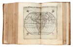
FIRST COMPLETE EDITION IN ITALIAN, 8vo (170 x 105mm.), title within woodcut side borders, woodcut portrait of Ptolemy, 60 double-page maps engraved by Giacomo Gastaldi, including 2 world maps and 5 of the Americas, old vellum, binding tightly rebacked retaining most of original spine
"THE VERY FIRST ATLAS OF THE NEW WORLD" (Nordenskiöld). The maps in this edition were designed by Giacomo Gastaldi. Most of the thirty-four maps of the modern world are entirely new, including seven relating to the Americas. Amongst these is Nueva Hispania tabula nova, showing the Mississippi and Florida area, which is the first separate printed map of the region. This small-format edition of Ptolemy was the most comprehensive world atlas before the publication of Ortelius's Theatrum in 1570. It is the first complete edition in Italian, following Berlinghieri’s verse paraphrase of 1482.
LITERATURE:
Burden 16 & 17; JCB (3) I 153; Nordenskiöld Collection 2, 214; Phillips, Atlases 369; Sabin 66502; Shirley, British Library T.PTOL-9a
PROVENANCE:
Portsmouth City Libraries, inkstamps (one cancelled) at foot of title, verso of title and last leaf
You May Also Like


