Fine Books and Manuscripts, Including Americana
Fine Books and Manuscripts, Including Americana

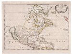
Sanson d'Abbevile, Nicolas | A scarce issue of an important map of North America
Lot Closed
January 25, 08:04 PM GMT
Estimate
3,000 - 5,000 USD
Lot Details
Description
Sanson d'Abbevile, Nicolas
Amerique Septentrionale. Paris: N. Sanson & P. Mariette, 1650
Copper-engraved map (sheet size: 438 x 578 mm). Original outline color.
The scarce second state of this important map of North America, by the founder of the French School of cartography.
The present map is arguably the most geographically progressive portrayal of the continent made at the time, and was not superseded until Vincenzo Maria Coronelli's map of 1688. Importantly, it is the first map to depict the Great Lakes in a recognizable form, and the first to name Lake Ontario and Lake Superior. In his rendering of the region, Sanson benefited from having received a copy of The Jesuit Relations (1649), a detailed account by French missionaries who had traveled in the region. To the north, a mysterious strait weaves over "New South Wales" on Hudson's Bay, terminating in the interior of the continent, a blank space labeled as "Mer Glaciale." This alludes to the existence of a much hoped-for Northwest Passage. On the eastern seaboard, the map notes "N[ouvelle] Amsterdam" in the place of present day New York, and is the first printed map to label "N[ouvelle] Suede," referring to the Swedish colony centered on Fort Christina, founded on the site of present-day Wilmington, Delaware in 1638. To the far southwest, Sanson based his depiction on the Father Alonso Benavides Memorial (1630), a travel account of New Mexico. It is the first printed map to label "S[anta] Fe" (which is incorrectly shown to be on the banks of the Rio Grande), and the domains of various native tribes such as the "Apache," "Navajo," and the "Taosij" (Taos). To the west, California is shown as a large island, and features some of the same nomenclature as found on Johannes de Laet's map of 1630.
REFERENCE
Burden, I:294 (state 3); Leighly 33:7; McLaughlin 12; Pastoreau; Wheat 39