
Property from the Buzz Aldrin Family Trust
[Apollo 11]
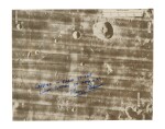
LUNAR SURFACE FLOWN Apollo 11 LM Lunar Surface Map, Maskelyne, Signed by Buzz Aldrin
Auction Closed
July 26, 06:15 PM GMT
Estimate
15,000 - 20,000 USD
Lot Details
Description
[APOLLO 11]
LUNAR SURFACE FLOWN Apollo 11 Lunar Surface Map, Maskelyne, from: LM Lunar Surface Maps, Part No. SKB32100080-371. [Houston, Texas: NASA, Manned Spacecraft Center, 1969]
10 1/2 by 8 1/2 inches. Black & white lunar surface map on DuPont Chronopaque® film. This lot will be accompanied by a Typed Letter Signed from BUZZ ALDRIN.
SIGNED AND INSCRIBED BY BUZZ ALDRIN IN BLUE INK, "CARRIED IN EAGLE TO THE LUNAR SURFACE ON APOLLO XI/BUZZ ALDRIN"
Directly from the Personal Collection of Apollo 11 Lunar Module Pilot Buzz Aldrin
LUNAR SURFACE FLOWN MAP—SHOWING THE PATH TO THE LANDING SPOT FOR HUMANKIND'S FIRST LUNAR LANDING
The Apollo 11 landing site, Tranquility Base, sits between the Maskelyne and Sabine craters, in the vast lunar plain known as the Sea of Tranquility ("Mare Tranquillitatis").
BUZZ ALDRIN'S provenance letter reads, in full: "On July 16th, 1969, Neil Armstrong, Mike Collins and I lifted off from Pad 39A at the John F. Kennedy Space Center on our journey to perform humankind's first landing on the Moon at the Sea of Tranquility.
This lunar surface map shows part of the path of the Lunar Module Eagle during Powered Descent Initiation (PDI) as we passed over the Maskelyne Crater on our way to Tranquility Base. This map provides a continuous view of the predicted flight path of the Lunar Module (LM) from approximately 210 miles to 75 miles out from the lunar landing site. The numbers starting with “2+40” are the minutes since the descent engine fired starting the descent to the surface and continue to “5+00” that would place us approximately 75 miles from the landing site. The map provides a scale in nautical miles and the names of landmark craters, including Maskelyne, Maskelyne B, Maskelyne G, and Censorinus J Craters. The map also provides the longitudinal coordinates Eagle would pass over as it descended toward the landing site at Tranquility Base.
This lunar surface map is one of the few objects carried to the lunar surface and is also a rare example of an astronaut flight-certified object used during our mission to be the first humans to land on the Moon."
REFERENCES:
NASA. Apollo 11 Stowage List. Mission AS 506 CM 107/LM-5. Houston, Texas: Manned Spacecraft Center, July 15, 1969, p. 51 & 57
CONDITION REPORT:
To request a condition report for this lot, please email science@sothebys.com

