Travel, Photographs, Maps and Natural History
Travel, Photographs, Maps and Natural History

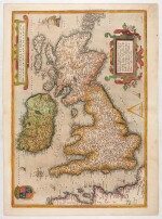
Abraham Ortelius | Angliae, Scotiae, Et Hiberniae, handcoloured engraved map, 1573
Lot Closed
November 17, 04:24 PM GMT
Estimate
500 - 700 GBP
Lot Details
Description
Abraham Ortelius
Angliae, Scotiae, Et Hiberniae, German edition. Antwerp: Egidus Coppens Dietsth, 1573
Copperplate engraved map (518 x 391mm. including margins), hand-coloured, oriented to the East, Latin text to verso, German text to recto, restoration to centrefold
This map, based on Gerard Mercator's earlier version, is notable for the strapwork surrounding the cartouche, five ships circumnavigating the isles, and the distinct Flemish twist on some of the place names. This includes 'Ormyskyrk' for 'Ormskirk and 'Dantre' for 'Daventry'. The printings of the 1570s were executed by Egidus Coppens Diesth, then in 1579 it was taken over by Christopher Plantin.
LITERATURE:
Koeman Ort 11; Shirley 86