The Passion of American Collectors: Property of Barbara and Ira Lipman | Highly Important Printed and Manuscript Americana
The Passion of American Collectors: Property of Barbara and Ira Lipman | Highly Important Printed and Manuscript Americana

Faden, William | One of the most important early maps of the United States
Auction Closed
April 14, 05:34 PM GMT
Estimate
4,000 - 6,000 USD
Lot Details
Description
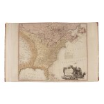
Faden, William
The United States of North America with the British and Spanish Territories according to the Treaty of 1784. London: Wm. Faden, Feb. 11, 1785
Copper-engraved map (540 x 815 mm). Full original color, hinged on guard; minor soiling and offsetting. Half red morocco over marbled paper covered boards, spine with raised bands in seven compartments, second with black gilt-lettered label; expertly rebacked to style, some rubbing to boards.
The rare fourth issue of one of the most important early maps of the United States
Faden's sequence of maps of the United States represents one of the most important cartographic descriptions of the newly independent republic. The present map is the fourth issue of the fourteen total versions, with each issue capturing a distinct stage in in America's development as a nation. The present example is the first to depict the United States with its boundaries as determined at the end of the Revolutionary War (as ratified at the Treaty of Paris, which went to effect in April of 1784). The map is colored to identify American, British, and Spanish territories, and the coast of Newfoundland, to which the French were granted fishing rights.
The Treaty of Paris established the new United States from the Atlantic to the Mississippi. The source of the Mississippi had not been determined, but the map offers two possible sites. The boundaries between New York, the Iroquois Nation, and Pennsylvania are nonexistent, but Vermont (although not yet ratified as a state), has been inserted between New York and New Hampshire, marking the beginning of a settlement of an old quarrel. Beyond these and other details that define this compelling cartographical composition, is the cartouche, which depicts slaves preparing barrels, bundles, and bales for export. This cartouche appeared in several issues of the map, and points to aspects of Britain's perception of America at this time — namely the benefits of commerce to both nations, and America's continuance of slavery.
REFERENCE
Celebration of My Country 103; Phillips, Maps 865; Stevens & Tree 80(d); Streeter sale 3784