
The Passion of American Collectors: Property of Barbara and Ira Lipman | Highly Important Printed and Manuscript Americana
The Passion of American Collectors: Property of Barbara and Ira Lipman | Highly Important Printed and Manuscript Americana
Champlain, Samuel de | The most important and complete edition, with the rare map
Auction Closed
April 14, 05:34 PM GMT
Estimate
90,000 - 120,000 USD
Lot Details
Description
Champlain, Samuel de
Les Voyages de la Nouvelle France occidentale, dicte Canada faits par le Sr Champlain Xainctongeois, Capitaine pour le Roy en la Marine du Ponant, & toutes les Descouvertes qu'il a faites en ce paos depuis l'an 1603. Iusques en l'an 1629. Paris: Pierre le Mur, 1632
Three parts in one, 4to (218 x 163 mm). Woodcut initials and headpieces, large engraved folding map, "Carte de Nouvelle France" (532 x 873 mm sheet), and 6 engraved illustrations in text; map with a few small holes along folds and old repairs along inner margin, minor spotting, offsetting of illustrations onto facing pages. 18th-century speckled calf, later morocco lettering piece, edges speckled; some light rubbing, expert restoration to joints as well as head and tail of spine, stamp to front free endpaper. Housed in custom quarter brown morocco slipcase.
The most important edition of Champlain—among the rarest and most significant cartographically illustrated works of travel and exploration to North America.
"Of all the editions of Champlain, this is the only complete one" (Church). Champlain's works stands alone as a full, accurate, detailed account of the first six voyages of Champlain through 1613, and a full account of the seventh voyage of 1615–17, and a brief note on the eighth.
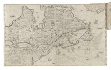
Champlain's Voyages is celebrated for its legendary map, with the fine example present here in Burden's second state. Burden writes that it "could be labeled the first to depict the existence of the entire Great Lakes network...The map covers the same territory as [the map] ... of c. 1616, but contains far greater detail, extending as far south as the Virginia colonies. The New Netherlands provides one of the areas of most interest in using nomenclature that is of unknown origin. The Hudson River is here called the 'Riviere des trettes, and Long Island Isle de l'Ascension.' Above these is a reference to an unidentified tribe, 'Habitation de sauuages maniganaticouoit.' The church depicted is clearly an indication of the Dutch presence in the region and must be construed as the first delineation of present-day New York City on a printed map."
Champlain's contribution to the exploration and mapping of North America is remarkable: he is the only individual who not only personally explored vast areas, but who also published maps and descriptions of what he encountered and observed. The present copy contains the cancelled leaves D2-3 replacing the offensive passage related to Cardinal Richelieu, as usual. The work was dedicated to the Cardinal, and the cancelled leaves replace a five-line passage that he apparently found objectionable, namely that great princes might know well how to conduct the government of a kingdom, and yet not know how to sail a ship.
With the rare and important map
PROVENANCE
Jean R. Perrette (bookplate; Christie's New York, 5 April 2016)
REFERENCE
Celebration of My Country 3; Burden 237 (state 2); Church 420, 446; Cumming, Skelton, and Quinn, Discovery of North America 286-7; Fite and Freeman 132-134; Heidenreich "An Analysis of the 17th Century Map 'Nouvelle France'" in Cartographica, Vol. 25, No. 3, 89-97; Heidenreich and Dahl, "The French Mapping of North America" in The Map Collector, 13:4-5; Kershaw 78-83; Lande 118; Pilling, Proof Sheets 464; Sabin 11839; Schwartz and Ehrenberg 89, pl. 48; Streeter sale 3631; Stokes 127 and 141