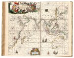
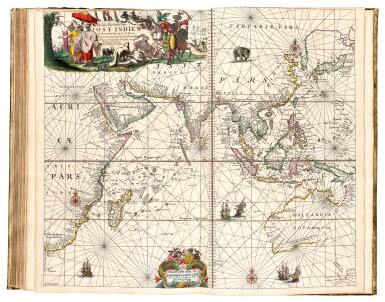
Keulen. De Groote Nieuwe Vermeerderde Zee-Atlas ofte Water-Werelt. 1685, fine hand-colouring
Auction Closed
July 28, 03:29 PM GMT
Estimate
40,000 - 60,000 GBP
Lot Details
Description
KEULEN, JOHANNES VAN
De Groote Nieuwe Vermeerderde Zee-Atlas ofte Water-Werelt. Amsterdam: Johannes van Keulen, 1685
Folio (528 x 330mm.), engraved frontispiece and 40 double-page maps, all with contemporary hand-colour, 12pp. text, contemporary Dutch vellum, covers gilt with central arabesque and panels, a few maps lightly shaved or shorter, lacking ties, slightly worn at places
A VERY GOOD EARLY EDITION WITH EXQUISITE CONTEMPORARY HAND-COLOUR. The family business established by Johannes van Keulen came to dominate Dutch chart publishing until the late eighteenth century. This large compilation contains maps of northern and Baltic navigation, southern and western navigation, the Mediterranean, Africa, and America.
The collection of maps differs slightly from what is listed in Koeman. This copy has Pascaert Van Texel. Tot aen Bergen als mede de Belt bound instead of Paskaart Van een Gedeelte der Noort Zee Beginnende van de Maas tot Dronte. Furthermore the map Nieuwe Paskaart Van de Zoute Eylanden has been added.
LITERATURE:
cf. Koeman Keu 13 (39 maps, see footnote)
PROVENANCE:
"J. Ven...?, 163 Avenue Molière, Bruxelles", inscription to front free endpaper