Travel, Atlases, Maps and Natural History
Travel, Atlases, Maps and Natural History

Hunter. Correspondence relating to his classified "Secret" Map of Arabia and the Persian Gulf. 1905-6
Auction Closed
July 28, 03:29 PM GMT
Estimate
20,000 - 30,000 GBP
Lot Details
Description
ARABIA ̶ CAPTAIN FREDERICK FRASER HUNTER
Letterbook, containing correspondence on research and preparation for his classified 'Secret' Map of Arabia and the Persian Gulf (1908)
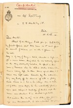
comprising c.130 items roughly arranged by correspondent, primarily inbound letters to Hunter but also retained drafts of outbound letters, telegrams, and some copy letters, many items marked "Secret" or "confidential", principal correspondents including: Col. F.B. Longe, Surveyor-General of India, including his letter of appointment ("...I want you to compile a map of Arabia & the Persian gulf - in conjunction with Capt Tandy & Mr Lorimer of the Foreign Dept, Capt. Tandy will put you all right professionally & Lorimer will give you all the information. It is strictly confidential..."), 7 August 1905; other senior members of the Survey of India such as T.F.B. Renny-Tailyour, SG. Burrard, and WJ Bythell; representatives of the Indian Foreign Office, Simla ("...A great deal of fresh detail of the Arabian Coast in the Persian Gulf from Kuwait to Sazwa Bay including the Country inland [...] has recently been received which shows great alterations & additions to existing maps to be necessary", Hunter to the Asst Surveyor General, Simla, 4 January 1906), the Intelligence Branch, and the Imperial Library; Captain M. O'C. Tandy, extensive series of lively letters (for example discussing the explorer and political agent G. W. Bury "he also undertook two journeys into the interior during which he made the map in 21 sheets, he went disguised as an Arab & is confident that no one suspected that he was anything else, when we were up country however we met chiefs from the districts he had visited & they assured us that they knew all the time that he was a Christian", 15 June 1906); J.C. Lorimer, extensive series on the progress of the project such as the controversy over the transliteration of names, ("...The chief changes from my system are the use of Q instead of K in some cases, the showing of final H even when silent, and the omission of the vowel before or after (') where there is no vowel in Arabic...", 7 July 1906); the correspondence discussing recent travels in Arabia, information supplied by political agents and others, Hunter's research including maps, charts, and other materials (many of them confidential or secret) supplied to him to produce his map, the progress of the project including redrawing sections, decisions on typography, the transliteration of Arabic, and related subjects; altogether c.240 pages, various sizes, 1905-6, with two printed maps and one telegram loosely inserted, bound in a folio volume, green half calf, spine labelled "Map of Arabia Notes 1905-6 | F.F. Hunter | Vol. 1"; nicks and wear at edges, binding rubbed
AN IMPORTANT SOURCE REVEALING THE EXTENSIVE AND DETAILED WORK BEHIND THE PRODUCTION OF A MILESTONE IN THE MAP-MAKING OF THE ARABIAN PENINSULA. When Frederick Fraser Hunter (1876-1959) joined the Survey of India from the Indian Army in 1905 he was ordered to produce an up-to-date map of the Arabia. He was friends with William Shakespear (see lot 211) and was well connected with the political agents and intelligence officers who were at this time highly active gathering new information about a region that was of ever-increasing strategic significance. As this volume of correspondence reveals, reports and maps coming from this intelligence network provided much new topographical detail for his map. The series of letters by Captain Tandy, a key collaborator with extensive experience in the region, is particularly revealing in providing analysis of topographical details provided by travellers and spies.
Hunter's map was produced to accompany John Gordon Lorimer's Gazetteer of the Persian Gulf and the two men worked very closely together, meaning that the letters from Lorimer in the current volume give particular insight into the progress of the map-making project. Hunter later reminisced on their time together: "Mr Lorimer, the draughtsman, and myself spent the winter of 1905-6 in the Foreign Office at Simla - a building designed for summer use. We worked from ten to fourteen hours a day, often in overcoats and mittens, with our ink constantly freezing: good draughtsmanship was difficult." (Hunter, 'Reminiscences of the Map of Arabia and the Persian Gulf', Geographical Journal, 54 (1919), p.356). Disagreements over transliteration delayed publication, but also gave an opportunity to redraw and improve the map, which was finally published in 1908 but, given its use of intelligence sources, was given a "Secret" classification.