
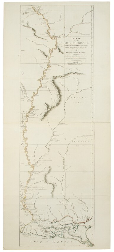
ROSS, LIEUTENANT | Course of the Mississippi from the Balise to Fort Chartres; taken on an Expedition to the Illinois in the latter end of the year, 1765. London: Robert Sayer, 1 June, 1775
Lot Closed
May 27, 06:29 PM GMT
Estimate
3,000 - 4,000 USD
Lot Details
Description
ROSS, LIEUTENANT
Course of the Mississippi from the Balise to Fort Chartres; taken on an Expedition to the Illinois in the latter end of the year, 1765. London: Robert Sayer, 1 June, 1775
Engraved map, two joined sheets (overall size: 19 7/8 x 45 3/4 in.), outline in color; old folds, instances of expert restoration to margins.
The first large-scale map of the Mississippi River
In the 1763 Treaty of Paris, which ended the French and Indian War, the east bank of the Mississippi was transferred from French to British sovereignty. And in 1765, Lieutenant Ross was sent on an expedition up the river as far as Illinois. Upon his return, he created a manuscript map focused on the great river that added his expedition's observations to the most recent French cartographical information, particularly that contained in D'Anville's map. The Ross map provided the first detailed, large-scale look at the river for its entire length, with the scattered French settlements and Native American tribal regions along its banks. Interestingly, the east bank features far more detail than the opposing side, as Ross and other British surveyors were technically only permitted to explore the British side of the river, which henceforth represented the western boundary of the English colonies. The chart begins at the top in Illinois where the French had established Fort de Chartres in 1720 on the east bank of the river, south of St. Louis and the confluence of the Illinois River.
The map was first published by Robert Sayer on 1 June 1772. This second issue of 1775 shows many alterations in the neighborhood of New Orleans, including the addition of Forts St. Leon and St. Mary.
REFERENCE:
Stevens & Tree, "Comparative Cartography" 31b (in Tooley, The Mapping of America); Phillips, A List of Maps of America 439