
Property from a Distinguished Private Collection
MITCHELL, SAMUEL AUGUSTUS | A New Map of Texas Oregon and California with the Regions Adjoining. Compiled from the most recent authorities. Philadelphia: Published by S. Augustus Mitchell, 1846
Lot Closed
May 27, 07:04 PM GMT
Estimate
5,000 - 7,000 USD
Lot Details
Description
Property from a Distinguished Private Collection
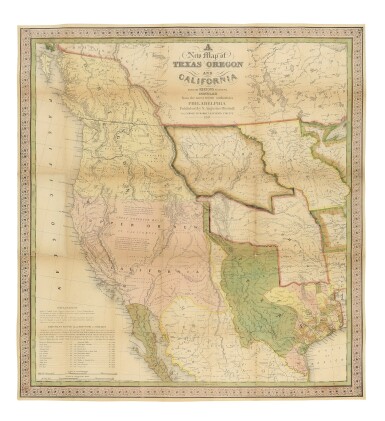
MITCHELL, SAMUEL AUGUSTUS
A New Map of Texas Oregon and California with the Regions Adjoining. Compiled from the most recent authorities. Philadelphia: Published by S. Augustus Mitchell, 1846
Engraved folding pocket map (22 3/4 x 20 7/8 in.; 557 x 530), engraved by H. N. Burroughs, full contemporary handcoloring, scrollwork border; lightly browned at folds, with some repaired fold separations and tiny holes at intersecting folds, lightly faded. Without the letterpress Accompaniment. Handsomely framed and glazed with UVIII Plexiglass.
A landmark western map and one of Mitchell's most popular and important pocket maps, representing "a great step forward, in that it is among the first by a commercial cartographer to utilize the recent explorations that had bounded and determined the nature of the Great Basin. … Because of its popularity, this map of the West exerted great influence, not only with the public but on other commercial cartographers" (Wheat). The map depicts the western portion of the United States to the Pacific, with the Indian Territory, Missouri Territory, Iowa, and portions of the states of Missouri, Arkansas, Louisiana, and Wisconsin, as well as northern Mexico and part of British Columbia, illustrating in detail the trans-Mississippi region on the verge of the Mexican-American War.
Texas is elaborately detailed, with the Rio Grande as its southern border; Oregon is shown to extend to 54° 40'; and the Santa Fe Trail and the Oregon Trail are both detailed, the latter with a table of distances of the "Emigrant Route from Missouri to Oregon" printed in the lower left corner of the map. Mitchell also issued A New Map of Texas Oregon and California as a separate wall map and as an inset map to the 1846 edition of his Reference & Distance Map of the United States.
REFERENCE:
Cowan 433; Graff 2841; Martin & Martin 36; Rumsey 0534; Sabin 49714; Streeter 4:2511; Wagner-Camp 122b; Wheat, Transmississippi 520; Wheat, Gold Regions 29