
BACHMANN, JOHN | Panorama of the Seat of War. Virginia, Maryland Delaware, and DC. New York: Charles Magnus, 1864
Lot Closed
May 27, 05:26 PM GMT
Estimate
2,500 - 3,500 USD
Lot Details
Description
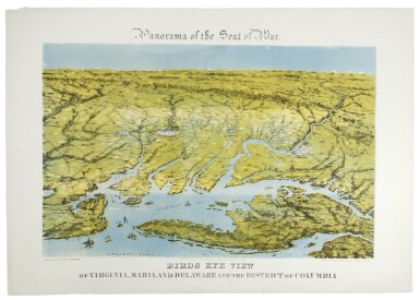
BACHMANN, JOHN
Panorama of the Seat of War. Virginia, Maryland Delaware, and DC. New York: Charles Magnus, 1864
Chromolithograph (sheet size: 24 x 34 1/2 in.), by Bachmann; backed onto tissue with neat repaired tears to margins, two just touching the title.
Third state of this striking, quasi-aerial view of the northernmost part of the east coast of the Confederacy, and the southernmost areas of the Union, including Washington
This third issue, printed after the smoke that was added to Manassas for the second issue had been removed again, has "many towns and battlefields ... added, especially around Richmond, Petersburg, and Fredericksburg" (Rumsey). This view, taken from the apparent vantage point some miles up in the outer atmosphere, was designed to serve as an individual stand-alone image (as here), but also to join with two other views by Bachmann which together form one continuous panorama of the east coast of the Confederacy. In all, Bachmann published six views covering the whole "Seat of the War." The present image covers an area which includes the locations of a number of well-known Civil War actions: Harper's Ferry, Fredericksburg, Chancellorsville, Spotsylvania, Manassas, Petersburg and Appomattox River, Richmond and environs.
John Bachmann was one of America's leading viewmakers, having been responsible for some of the finest New York City views. This innovative cross between view and map appears to have been his own invention, and it gives an intriguing and different perspective on the conflict.
(See previous lot.)
REFERENCE:
Stephenson Civil War Maps (1989) 2 & 3 (1st and 2nd states); Stephenson & McKee Virginia in Maps 239 (2nd state); Rumsey 2817; Reps 160