Fine Books and Manuscripts, Including Selections from the Collection of Barbara and Ira Lipman
Fine Books and Manuscripts, Including Selections from the Collection of Barbara and Ira Lipman

Clark, Richard | A scarce wall map of Fairfield County
Lot Closed
December 16, 09:54 PM GMT
Estimate
2,500 - 3,500 USD
Lot Details
Description
Clark, Richard
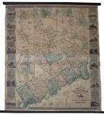
Clark's Map of Fairfield County, Connecticut. Philadelphia: Richard Clark, 1856
Lithographic wall map (sheet size: 1,537 x 1,467 mm). Full period hand-color; expertly repaired, backed with modern linen, edged with silk, on contemporary rollers.
An elaborate and detailed wall map of Fairfield County, Connecticut
Fairfield is the site of some of New York City's most prestigious suburbs. Each township is separately colored, with the properties of numerous individual landowners located. The map is flanked by sixteen inset views of important Fairfield sites, including numerous private residences, and the Court House in Bridgeport. The views are separated by ornamental Victorian scrollwork. There are twenty-four inset plans of Fairfield towns and villages, including Greenwich, Stamford, Ridgefield, New Canaan, Westport, Danbury, Bridgeport, Southport, Sharon, Bethel, Fairfield, Norwalk, South Norwalk, Newtown, New Fairfield, Brookfield, and Cos Cob. The map was drawn from a survey by J. Chace, W. J. Barker, and N. Hector, and lithographed by Wagner & McGuigan in Philadelphia.
The only 19th-century map of the county listed in Phillips' America
REFERENCE
Not in Rumsey; Thompson, Maps of Connecticut 176; Phillips, America 276