
Evans, Lewis. The Streeter copy of "One of the most important maps published in America before Independence"
Lot Closed
October 15, 04:57 PM GMT
Estimate
140,000 - 180,000 USD
Lot Details
Description
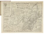
EVANS, LEWIS
GEOGRAPHICAL, HISTORICAL, POLITICAL, PHILOSOPHICAL AND MECHANICAL ESSAYS. THE FIRST, CONTAINING AN ANALYSIS OF A GENERAL MAP OF THE MIDDLE BRITISH COLONIES IN AMERICA; AND OF THE COUNTRY OF THE CONFEDERATE INDIANS... PHILADELPHIA: BENJAMIN FRANKLIN AND D. HALL, 1755
4to (233 x 172 mm). 32 pages. Large engraved folding map "A General Map of the Middle British Colonies" (500 x 670 mm platemark, 532 x 708 mm sheet); marginal repair at lower left not affecting map, a few lights spots, just separating at folds at three points. Modern red morocco, housed in a blue cloth folding case.
The Streeter copy of "One of the most important maps published in America before Independence"
Lewis Evans was "the best geographer working in the English colonies in the mid-eighteenth century" (Pritchard & Taliaferro). His "General Map of the Middle British Colonies" was the first to delineate, with any degree of accuracy, the lands beyond the Appalachian Mountains, and the first to emphasize the importance of the Ohio Valley in Great Britain's battle with the French for dominance in North America.
The present lot includes the the landmark map in its second state, with the insertion of "The Lakes Cataraqui" just north of Lake Ontario, and the second edition of the text, first issue, without the addition of the R. and J. Dodsley name and address in the imprint. The second edition of Evan's text is essentially an exact re-setting of the first edition, with variations to pp. 6 and 11 and the numeral 2 inserted to the left of the signature on the directional line of the first two leaves of each quire.
The map was issued both with and without the Analysis, printed by Benjamin Franklin, in which Evans carefully acknowledges the sources upon which his map improved. Building upon his own "Map of Pennsylvania, New-Jersey, New-York, and the three Delaware Counties," Evans consulted an early state of Fry and Jefferson's "Map of the most inhabited part of Virginia" and William Mayo's "Map of the Northern Neck of Virginia." He also consulted Walter Hoxton's "Mapp of the Bay of Chesepeack, with the Rivers, Potomack, Potapasco, North East, and part of Chester" for his delineation of Chesapeake Bay. For Connecticut he looked to the maps of William Douglas and Thomas Pownall — to whom Evans dedicates the map in the cartouche at top left.
Evans's completed work is characterized by a wealth of dense information, notable for its description of both geography, and geomorphology and other natural features (he describes, for example, salt and limestone deposits, petroleum in western Pennsylvania, and coal in Ohio). Further distinguishing his efforts, Evans' knowledge of native tribes is remarkably well-documented, and noteworthy in its presentation of the Iroquois Confederacy as a geopolitical power in its own right. In the Analysis he cites as sources a number of Indian traders, giving special credit to "The Eagle, who had a good Notion of distances, Bearings and delineating."
Many compared Evans's work favorably to his contemporary John Mitchell's monumental "Map of the British and French Dominions in North America," Benjamin Franklin, for example, wrote that "When [Evans's map] is done, Dr. Mitchell's Map may perhaps be something improv'd from it" (Degrees of Latitude, p. 174). Evans's work indeed proved exceedingly influential, with sixteen subsequent editions being published over the next sixty years, all piracies except for one.
One of the most influential American maps of the eighteenth century, a foundational document in American westward expansion
REFERENCE:
Campbell 543; Church 1003; Evans 7412; Hildeburn 1412a; Howes E-226; Miller 606; Pritchard & Taliaferro 34; Sabin 23175; p.165; Stevens Nuggets I:1019; Streeter sale II:819 (first ed. of the text); The World Encompassed 255; Thomson 384; Winsor V:85.
PROVENANCE:
Frank S. Streeter (his sale, Christie's New York, 16-17 April 2007, lot 185)