Fine Books and Manuscripts, Including Americana
Fine Books and Manuscripts, Including Americana

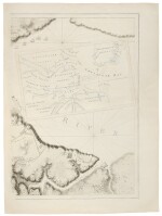
Des Barres, J.F.W. The very rare Des Barres chart of Yorktown
Lot Closed
October 15, 04:47 PM GMT
Estimate
10,000 - 15,000 USD
Lot Details
Description
DES BARRES, J.F.W.
[YORKTOWN]. [A PLAN OF THE POST OF YORK AND GLOUCESTER IN THE PROVINCE OF VIRGINIA. ESTABLISHED BY HIS MAJESTY'S ARMY UNDER THE COMMAND OF LIEUT. GENERAL EARL CORNWALLIS, TOGETHER WITH THE ATTACKS UNDER OPERATIONS OF THE AMERICAN & FRENCH FORCES COMMANDED BY GENERAL WASHINGTON AND THE COUNT OF ROCHAMBEAU, WHICH TERMINATED IN THE SURRENDER OF THE SAID POSTS AND ARMY ON THE 18TH OF OCTOBER 1781. SURVEYED BY CAPTN. FAGE OF THE ROYAL ARTILLERY]. LONDON: BRITISH ADMIRALTY, JUNE 4, 1782
Engraved chart with aquatint, one sheet only (of two), (sheet size: 33 1/4 x 24 3/4 in.; 845 x 629 mm). Outlined in color, with an inset of the lower Chesapeake and lower courses of the York and James Rivers; some expert restoration.
The very rare Des Barres chart of Yorktown
The [Atlantic Neptune] is the "most splendid collection of charts, plans and views ever published" (Rich). It was published at the charge of the British government for the use of the British Navy, and no expense appears to have been spared in the execution in order to render it a monument worthy of the nation. Due to the great cost of publication, this multi-volume atlas would probably have never seen the light of day if not for the worsening conditions in the American Colonies. It was imperative for the Admiralty to have a worthy sea atlas for the use of its fleet in American waters. Even then the work progressed slowly. The earliest charts were separately published and distributed to the Navy in 1775. New charts appeared regularly over the next seven years, with the emphasis shifting according to the course of events during the Revolution. Approximately 160 charts were produced before publication ceased in 1782, and no two examples of the atlas have the same collation.
The [Plan of the Posts of York and Gloucester], dated 4th June 1782, was the last of the charts to be published. Very few copies were printed before the atlas was discontinued, and it is an extraordinary rarity. The map was included in only one of the thirteen sets of the Atlantic Neptune at the Library of Congress examined by Coolie Verner. It is the "first British prototype to detail the situation around Yorktown at the time of the surrender" (Verner, [Yorktown], p. 251). The second, by William Faden, did not appear until 1785.
Present here is the right half only of the two-sheet map.
REFERENCE:
Degrees of Latitude 66; Phillips, Atlases 1198-1204; Rich, Bibliotheca Americana, I:249; Verner, "Maps of the Yorktown Campaign 1780-1781," in The Mapping of America 252