Travel, Atlases, Maps and Natural History
Travel, Atlases, Maps and Natural History
SOLD TO BENEFIT THE COLLECTIONS OF THE COLONIAL WILLIAMSBURG FOUNDATION
Loon | Klaer-lichtende noort-star ofte Zee-atlas, 1666
Auction Closed
November 12, 04:34 PM GMT
Estimate
60,000 - 80,000 GBP
Lot Details
Description
SOLD TO BENEFIT THE COLLECTIONS OF THE COLONIAL WILLIAMSBURG FOUNDATION
LOON, JOHANNES VAN
Klaer-lichtende noort-star ofte Zee-atlas; waer in vertoont wordt, De gelegentheydt van alle de zee-kusten des geheelen aerdtbodems. Amsterdam: Johannes van Loon, 1666
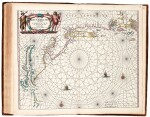
Folio (484 x 300mm), hand-coloured engraved title, with title and imprint on letterpress overslip, 34 double-page engraved maps, contemporary hand-coloured in outline, contemporary calf, spine gilt in eight compartments, occasional minor repairs (title repaired and strengthened to verso, small localised loss of colour), slight staining at places, rebacked partially retaining original spine, recornered, detailed condition report is available upon request.
FINELY COLOURED COPY OF THIS UNIQUE MARITIME ATLAS.
The biographical information on the mapmaker Johannes van Loon (1611-1686) is poorly documented. It is known, however, that he was a mathematical practitioner, who worked for various booksellers and shiphandlers in Amsterdam. "The sea-atlas by Johannes van Loon had a short but interesting development. It started with an edition containing 35 maps (increased to 47 maps in 1666), but the plates were sold to Joh. Janssonius van Waesberghe in the same year. The latter published the atlas in his name until 1706. The Klaer Lichtende Noort-ster was sold as well by two other booksellers; by Gilles van Loon (brother of Johannes?) in Amsterdam and by William Goeree at Middleburg. Van Loon's sea-atlas appeared shortly after Hendrik Doncker's sea-atlas. The charts show a certain relationship. In the 1666 edition and later editions, Van Loon also followed the example of Doncker's Introduction: an example of the charts, taking their regional arrangement as a course line over the seas" (Koeman).
UNRECORDED. According to Koeman, only one example is found of the 1666 edition with 34 maps. It is held by Yale, and has the imprint of Wilhelmus Goeree on an overslip. We are only able to trace three copies of the Klaer-lichtende noort-star sold in the past 100 years: Sotheby's, 1995, lot 108: Amsterdam, 1661 [1663], 39 maps; Sotheby's, 1980, lot 274: Amsterdam, 1666, 39 maps; Sotheby's, 1951, lot 383: Amsterdam, 1668, 42 charts.
The 34 maps include:
i. Pas-caerte van Groenland Ysland, Straet Davids en Ian Mayen eyland; hoemen de selvige van Hitland en de noord kusten van van Schotlandt en Yrlandt bezeylen mach, [Burden 364]
ii. Pascaert van Ruslant, Laplant, Finmarcken, Spitsbergen en Nova Zembla
iii. Pas-caerte om Achter Yrlandt om zeylen, van Hitlandt tot an Heyssant
iv. Pascaerte Vande Noort zee, Vertonende van Cales tot Dronten, en tusschen Doeveren en Hitlandt, al de gelegentheyt van havens bayen en revieren, alles op syn behoorlycke cours, veerheyt en brete, mede wat diepte, droogte, en anckergront men op ider plaets heeft. Nieulyckx int licht gebracht
v. Pascaerte vande Oost Zee, Van 't Eylandt Ruygen ofte Bornholm
vi. Pascaerte vande Zuyder-Zee, Texel ende Vlie-Stroom
vii. Pas-caerte van Texel tot ande Hoofden, begrypende in sich de Zee-custen
viii. Pascaerte van Engeland, Schotlant, Yerlant en een gedeelte van Franckryck
xi. Pascaerte vande Canaal; tusschen Engelandt en Vranckryck
x. Pas-caerte vant in comen Vande Canael Hoemen die sal aen doen
xi. Pascaerte van Hispania als Granada, Andaluzia, Portugael
xii. Pascaerte vande Bocht van Vrankryck, Biscayen
xiii. Pascaerte Van't Westelyckste deel vande Middelandsche Zee
xiv. Pascaerte Van't Oostelyckste deel vande Middelandsche Zee
xv. Pas-caerte van Barbaria
xvi. Pas-caerte vande Canarische Eylanden
xvii. Pascaerte vande Vlaemsche Eylanden
xviii. Pascaerte vande Soute Eylanden ofte Ilhas de Cabo Verde
xix. Pascaert van Rio Gambia
xx. Pascaerte van Africa
xxi. Pascaerte van Guinea
xxii. Pascaerte van Angola en Cimbebas
xxiii. Pascaerte Van't Westelyckste deel van Oost Indien, en de Eylanden daer onder begrepen, van C. de Bona Esperança tot C. Comorin
xxiv. Pascaerte van't Oostelyckste deel van Oost-Indien: met alle de Eyelanden daer onder gelegen van Cabo Comorin tot aen Iapan
xxv. Pascaerte vande Zuyd-Zee tusschen California en Ilhas de Ladrones
xxvi. Pascaerte van Nova Hispania, Peru en Chili, [Burden 369]
xxvii. Pascaerte van Straet van Magalaen Synde 't Suydlyckste gedeelte van America, van C. S. Antonio tot C. de Hoorn; en inde Zuyd-Zee tot Val Parayso
xxviii. Pascaarte van Brasil, van Rio Grande tot Rio de la Plata
xxix. Pascaerte van't Westelyckste deel vande Spaense Zee, Tusschen Brasil, de Zoute en Vlaemse Eylanden, en voort westwart op
xxx. Pascaerte van de cust van Guaiana ofte de Wilde Cust; en't Noorder deel van Brazil, met de gelegentheyt vande vermaer: de Rivier van de Amazones, tusschen villa d'Olinda de Pernambuco en R. Oronoque
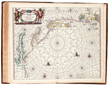
xxxi. Pascaarte vande vaste Cust en Eylanden van Westindien, Als mede de Virginis en Nieu-Nederland, van C. Droge tot C. Cod, [Burden 367]
xxxii. Pascaerte vande Caribes, S. Iuan de Porte Rico, de oosthoeck van I. Spangnola als mede de vaste cust van Nueva Andalusia met de eylanden daer omtrent gelegen. Nieu-lyckx uutgegeven
xxxiii. Pas caerte van Nieu-Nederland en de Engelsche Virginies; Van Cabo Cod, tot Cabo Canrik, [Burden 366]
xxxiv. Pas-caerte van Terra Nova, Nova Francia, Nieuw Engeland en de grote Rivier van Canada, [Burden 365], second state
LITERATURE:
cf. Koeman Loon 1,2 and 3; cf. Shirley M.LOON-1a and b; Burden 364-367, and 369