Travel, Atlases, Maps and Natural History
Travel, Atlases, Maps and Natural History

Cook | Complete set of the voyages, 9 volumes
Auction Closed
November 12, 04:34 PM GMT
Estimate
20,000 - 30,000 GBP
Lot Details
Description
COOK, CAPTAIN JAMES
Complete set of first editions of the voyages, comprising:
First Voyage--John Hawkesworth. An Account of the Voyages by the order of his present Majesty for making discoveries in the Southern Hemisphere, and successively performed by Commodore Byron, Captain Wallis, Captain Carteret and Captain Cook, in the Dolphin, the Swallow, and the Endeavour. London: Printed for W. Strahan and T. Cadell, 1773, FIRST EDITION, 3 volumes (290 x 228mm.), 51 engraved plates, charts and maps (most folding or double-page), contemporary speckled calf, morocco spine labels, spine gilt in 6 compartments, [Beddie, BCJC 648; Hill (2004) 782; Sabin 30934], [George Elliott, signature; Esme Nicoll, England, Honiton, bookplate], lacking two leaves in volume 1 (“Directions for placing the cuts and charts”), occasional minor tears or staining, slight worming to beginning of volume 2, bindings expertly repaired and rebacked retaining original spines
Second Voyage--James Cook. A Voyage towards the South Pole, and round the world. London: Printed for W. Strahan and T. Cadell, 1777, FIRST EDITION, 2 volumes, (294 x 227mm.), engraved portrait frontispiece of Cook by J. Basire after W. Hodges, 63 engraved plates, charts and maps (most folding or double-page), double-page printed table (usually found as folding), contemporary tree calf, flat spine gilt, morocco spine labels, [Beddie, BCJC 1229; cf. Hill (2004) 358; Sabin 16245], [A. Burnaby, signature throughout; Baggrave Library, book labels], occasional faint offsetting, a few small scuffs or repairs to covers, expertly rebacked retaining original spines
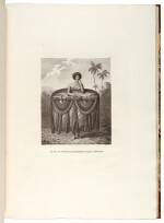
Third Voyage--James Cook and Captain James King. A Voyage to the Pacific Ocean ... for making Discoveries in the Northern Hemisphere. London: W. and A. Strahan, 1784, FIRST EDITION, 3 volumes text and atlas, together 4 volumes, text: (282 x 225mm.), 24 engraved charts and plates (some folding), folding printed table, advertisement leaf at end of volume 3, atlas: (562 x 402mm.), 2 maps (folding or double-page), and 61 plates, text in contemporary tree calf, flat spines elaborately gilt, morocco spine labels, atlas in later half calf bound to style, flat spine gilt, [Beddie, BCJC 1552; cf. Hill (2004) 361; Sabin 16250], [Sir William Jenningham, armorial bookplate], text volumes with occasional spotting, bindings expertly refurbished to style, with a new upper cover to volume 2
together 9 volumes