Thomas Sulman
British Prospect Map of Manhattan Island, New York
1876
Complimentary Shipping
Price:
International shipping available
Customs duties and taxes may apply.
Ships from: London, United Kingdom
Taxes not included
VAT and other taxes are not reflected in the listed pricing. Read more
Authenticity guaranteed
We guarantee the authenticity of this item.
Details

Description
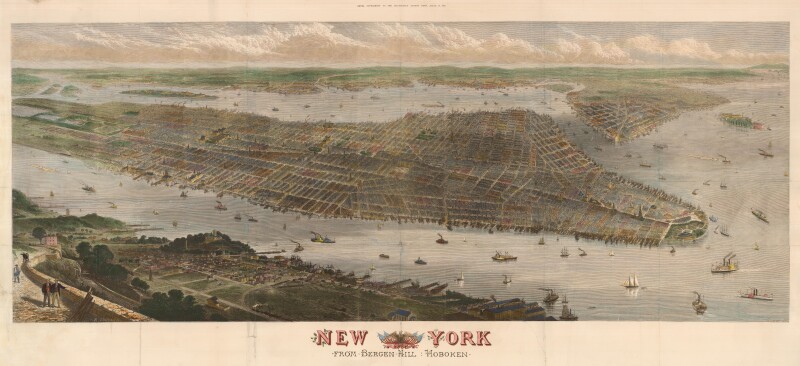
A prospect map of Manhattan, by Thomas Sulman.
- Thomas Sulman (British).
- New York from Bergen Hill: Hoboken.
- London: 1876.
- Wood-engraving with hand color.
- This work is presented unframed.
An impressive panoramic view of Manhattan Island, drawn by Thomas Sulman and engraved by Robert Loudan for a supplement to the Illustrated London News, celebrating the centennial of the United States.
The elevated viewpoint of Bergen Hill allows the grid street plan to be visible.
On the left is Central Park, showing Olmstead's redesign as completed in 1873, three years before this prospect was published.
On the right is Brooklyn, with the two towers of Brooklyn Bridge shown, seven years before it opened.
On the Hudson and East rivers are illustrations of river traffic including paddle steamers.
The Illustrated London News was the world's first illustrated weekly news magazine, founded in 1842, using wood-engraving to produce illustrations cost-effectively.
To make subscriptions more attractive the publishers regularly issued 'supplements' for subscribers only, with a larger format illustration, often city prospects such as this.
Condition Report
 Very Good
Some minor repairs to original folds.
Laid on archival canvas.
Product is used.
Dimensions
Language
Subject
Conditions of Business
Please note that the cancellation right for EU/UK purchasers applies to this item. Please read Condition 19 of the Buy Now Marketplace Conditions of Business for buyers for more information. Read more here.