Nicolas de Fer
French Map of the Peloponnese Region
Circa 1715
Complimentary Shipping
Price:
International shipping available
Customs duties and taxes may apply.
Ships from: London, United Kingdom
Taxes not included
VAT and other taxes are not reflected in the listed pricing. Read more
Authenticity guaranteed
We guarantee the authenticity of this item.
Details

Description
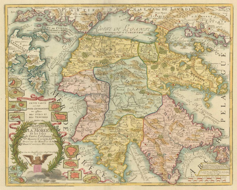
A map of the Peloponnese and part of Greece and the Greek Isles.
- Nicolas de Fer (French).
- Cette Carte est faite Pour L'Intelligence des affaires Des Turcs et des Venetiens dans le Peloponese Aujourd'huy La Morée et les Isles de Zante, Cefalonie, Ste Maure, Cerigo. &c.
- Paris: circa 1715.
- Unframed.
Engraved by Liébaux, this detailed and finely rendered map of the Peloponnese is designed to show the respective possessions of the Venetians and Turks during the War of the Holy League (1683-98). Around the title cartouche are medallion-inset town plans of the towns captured by the Venetians. However, their dominion in the Morea was short-lived as it was returned to the Turks at the Treaty of Passarowitz in 1718 at the conclusion of the Turkish-Venetian war (1714-18).
Condition Report
 Good
GoodMinor signs of age and wear.
Product is used.
Dimensions
Language
Subject
Conditions of Business
Please note that the cancellation right for EU/UK purchasers applies to this item. Please read Condition 19 of the Buy Now Marketplace Conditions of Business for buyers for more information. Read more here.