Jean Baptiste Louis Clouet
French and Spanish Double-Hemisphere World Map
Louis Joseph Mondhare
1788
Complimentary Shipping
Price:
International shipping available
Customs duties and taxes may apply.
Ships from: London, United Kingdom
Taxes not included
VAT and other taxes are not reflected in the listed pricing. Read more
Authenticity guaranteed
We guarantee the authenticity of this item.
Details

Description
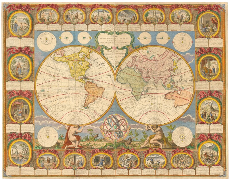
A beautiful double-hemisphere world wall map, with the title in French and Spanish, with the Western Hemisphere held aloft by Atlas, the Eastern by Hercules.
- Jean Baptiste Louis Clouet (French, 1730-1790).
- Paris & Cadiz: Louis Joseph Mondhare, 1788.
- Carte General de la Terre ou Mappe Monde Avec Les Quatre Principeaux Sistemes.
- The borders, 175mm wide at the sides and 160mm at the bottom, contain twenty vignette scenes from the Old Testament, all in full color, with short texts in French and Spanish.
- Around the map are nine astronomical diagrams.
- This work is presented unframed.
The cartography includes a measure of fallacy and anomaly: in North America the 'Mer de l'Ouest is shown, as is the North West Passage of de Fonte; and despite Hawaii being marked as the place of Captain Cook's death (erroneously dated '17 Fevr. 1778' instead of 14th Feb 1779), the map has not been corrected to show the discoveries made by Cook in the decade before his death. Thus New Zealand is a partial outline, although circumnavigated in 1770-1 and Australia is still connected to Tasmania and Espirito Santo.
Surviving copies of this example are rare.
Condition Report
 Very Good
Later colored.
Four sheets conjoined, laid on canvas to reinforce numerous paper cracks.
Some small areas of paper loss and marginal damage expertly repaired, with some missing. filled.
Product is used.
Dimensions
Language
Subject
Conditions of Business
Please note that the cancellation right for EU/UK purchasers applies to this item. Please read Condition 19 of the Buy Now Marketplace Conditions of Business for buyers for more information. Read more here.