John Calvin Smith
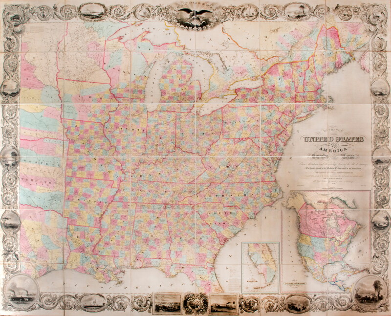
Map of the United States of America
Sherman & Smith
1849
Complimentary Shipping
Price:
International shipping available
Customs duties and taxes may apply.
Ships from: London, United Kingdom
Taxes not included
VAT and other taxes are not reflected in the listed pricing. Read more
Authenticity guaranteed
We guarantee the authenticity of this item.
Details

Description
A map of the United States by John Calvin Smith.
- John Calvin Smith (American, c. 1809-1890).
- Map of the United States of America, Including Canada, and a large portion of Texas, Showing Base Meridian and Township Lines of the U.S. Surveys, Including Lands alotted to the Indian Tribes west of the Mississippi, The Various Internal improvements.
- New York: Sherman & Smith, 1849.
- It was first published in 1843 with updates and revisions until 1852.
- Signature of Edouard Diodati (1789-1860) on the back board. He was director of the Geneva Public Library from 1820 to 1845, prison chaplain (1828-1840), moderator of the Society of Pastors (1837) and member of the Consistory (1846-1851). He also taught aesthetics and modern literature (1839-1840), homiletics and apologetics (1840-1860) at the academy of Geneva.
- Large format map of the United States within an impressive decorative border, dissected on 36 sheets.
- Laid on linen and housed in publisher’s black cloth boards with gilt title on upper board.
The map stretches from Austin, Texas to the east coast and from Lake Superior to the Gulf of Mexico. There are cantons of the United States and the lands allocated to the various Indian tribes west of the Mississippi River. When published, this map was hailed as the largest, best and most detailed map of the United States ever published.
There are two medallions, one showing South Florida and the Everglades, the other representing North America as a whole in the post-American-Mexico War configuration, Texas being illustrated in its entire extent, including the North enclave. Upper California includes the “Mormon Colony” on the site of present-day Salt Lake City and identifies the gold-rich region near the Sacramento River. The attempt to colonize New Helvitia by Johann Augustus Sutter is noted.
It is worth noting the impressive decorative border where dacanth leaves embrace countless vignettes of American flora and fauna, important cities, monuments and much more. At the top of the map is a large eagle gripping the shield of the United States, surrounded by 26 stars, each representing a state and containing a vignette. Four additional, partially shaded stars include l’Iowa, Wisconsin, Texas and another possible state.
Condition Report
 Very Good
Minor signs of age and handling.
Product is used.
Dimensions
Language
Subject
Conditions of Business
Please note that the cancellation right for EU/UK purchasers applies to this item. Please read Condition 19 of the Buy Now Marketplace Conditions of Business for buyers for more information. Read more here.