
John Senex
Map of Ireland
John Senex F.R.S., the Globe against St Dunstans Church
1712 - 1728
Complimentary Shipping
Price:
International shipping available
Customs duties and taxes may apply.
Ships from: London, United Kingdom
Taxes not included
VAT and other taxes are not reflected in the listed pricing. Read more
Authenticity guaranteed
We guarantee the authenticity of this item.
Details

Description
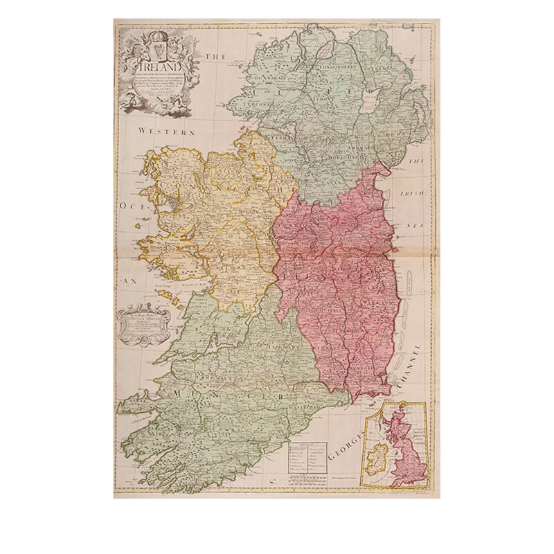
An English map of Ireland.
- John Senex (English).
- Ireland Corrected from the Latest Observations Divided into its Provinces, Counties and Baronies. Shewing the Principal Roads, and the Distances of Places, in Common reputed Miles. by Inspection Where Barracks are Erected &c. By John Senex F.R.S.
- Fleetstreet, London: John Senex F.R.S., the Globe against St Dunstans Church: 1712 (-1728).
- Includes inset map of the British Isles.
- Double-page engraved map on two sheets joined, with full contemporary hand-coloring, decorative title cartouche surmounted by a harp with a crown above, key table and scale bars.
- This work is presented framed.
John Senex (1678-1740) was one of the foremost mapmakers in England in the early eighteenth century. He was also a surveyor, globemaker and geographer. As a young man, he was apprenticed to Robert Clavell, a bookseller. He worked with several mapmakers over the course of his career, including Jeremiah Seller and Charles Price. In 1728, Senex was elected as a Fellow of the Royal Society, a rarity for mapmakers. The Fellowship reflects his career-long association as engraver to the Society and publisher of maps by Edmund Halley, among other luminaries. He is best known for his English Atlas (1714), which remained in print until the 1760s. After his death in 1740, his widow, Mary, carried on the business until 1755. Thereafter, his stock was acquired by William Herbert and Robert Sayer (maps) and James Ferguson (globes).
Condition Report
 Good
GoodLeft margin trimmed to neat line.
Some light creasing at edges with a couple of tiny marginal tears.
Product is used.
Dimensions
Framed Height: 42.12 inches / 107 cm.
Framed Width: 30.43 inches / 77.3 cm
Language
Subject
Conditions of Business
Please note that the cancellation right for EU/UK purchasers applies to this item. Please read Condition 19 of the Buy Now Marketplace Conditions of Business for buyers for more information. Read more here.