
Property from a Distinguished Private Collection
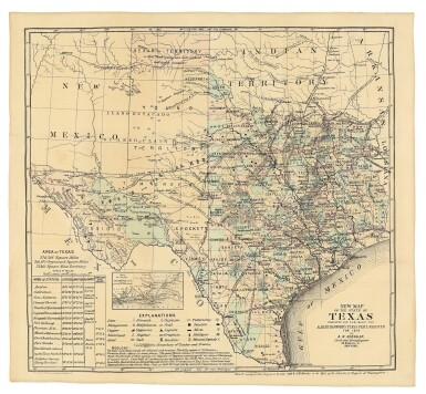
ROESSLER, ANTON R. | New Map of the State of Texas Prepared and Published for Albert Hanford's Texas State Register for 1876. New York: Ed. W. Welcke & Bro. Photo-Lithographers, 1876
Lot Closed
May 27, 07:05 PM GMT
Estimate
3,000 - 5,000 USD
Lot Details
Description
Property from a Distinguished Private Collection
ROESSLER, ANTON R.
New Map of the State of Texas Prepared and Published for Albert Hanford's Texas State Register for 1876. New York: Ed. W. Welcke & Bro. Photo-Lithographers, 1876
Lithographed map (19 3/4 x 21 3/8 in.; 498 x 543 mm), full contemporary handcoloring, inset "Map of the Vicinity of Galveston City." Accompanied by a first edition of Albert Handford's Texas State Register for 1876 (Galveston: Published by A. Hanford, 1876), with which the map was issued; lightly faded, the Register in stab-sewn original printed wrappers; stained and chipped with minor restoration. Map handsomely framed and glazed with UVIII Plexiglass.
A small format version of Roessler's celebrated map of 1874, aimed at emigrants and focused on the geological riches of the Lone Star State. The Texas State Register in which Roessler's map was issued also includes a brief essay by the cartographer-geologist, "Some Account of the Mineral Wealth of Texas," which claims that "Texas is, or will be, the wealthiest State in the Union, possessing as she does great agricultural capabilities, all the varieties of soils minerals, and useful rocks known to exist in the world."