
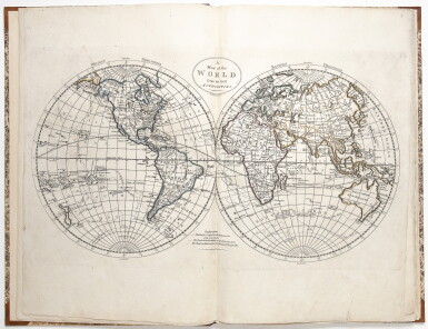
Carey, Mathew. An apparently unrecorded variant of Carey's General Atlas
Lot Closed
October 15, 04:32 PM GMT
Estimate
6,000 - 8,000 USD
Lot Details
Description
CAREY, MATHEW
GENERAL ATLAS, BEING A COLLECTION OF MAPS OF THE WORLD AND QUARTERS, THEIR PRINCIPAL EMPIRES, KINGDOMS, &C. ... (PRICE 7 DOLLARS 50 CENTS) ... PHILADELPHIA: PUBLISHED BY M. CAREY & SON, 1817
Folio (16 5/8 x 11 in.; 422 x 279 mm). Letterpress title incorporating a list of the maps). 24 engraved maps, all hand-colored in outline, contemporary manuscript numbering in the upper right corner of each map. Expertly bound to style in half calf over period marbled paper covered boards, flat spine in six compartments, second and third gilt lettered, others with a repeat decoration in gilt.
Maps in this variant edition include:
The maps in this rare edition are:
1. A map of the world from the best authorities.
2. A chart of the world, according to Mercators projection, shewing the latest discoveries of Capt. Cook.
3. A New and Accurate Map of North America from the best Authorities.
4. The British Possessions in North America from the latest Authorities
5. A Map of the United States of America
6. A New Map of South America From the Latest Authorities
7. Europe
8. Sweden, Denmark, Norway and Finland, from the best authorities
9. Russian Empire.
10. Scotland with the principal roads from the best authorities.
11. An accurate map of England and Wales with the principal roads from the best authorities
12. A Map of Ireland according to the best authorities
13. Holland or the Seven United Provinces, and the Netherlands
14. Germany
15. France divided into circles and departments
16. Turkey, in Europe and Hungary; from the best authorities.
17. Spain and Portugal.
18. Italy, and Sardinia, from the best authorities.
19. Switzerland According to the best authorities.
20. Poland.
21. Asia According to the best authorities.
22. China, divided into its great provinces according the best authorities.
23. An accurate map of Hindostan or India, from the best authorities.
24. Africa According to the best authorities.
An apparently unrecorded variant of Carey's General Atlas
Mathew Carey published the first American Atlas in 1795 (containing 21 maps) and the first General Atlas in 1796 (containing 45 maps). He republished the 1796 General Atlas in 1800, 1802 and 1804, and would publish a "second edition" of the atlas in 1811. That second edition was largely the same as the preceding, containing the maps from the 1804 General Atlas with the addition of a map of Louisiana from his 1805 pocket atlas. In 1814, Carey published a "third" edition of the General Atlas, the first major revision of his famed atlas, which contained 58 maps, and is considered by many to be the most desirable. That atlas contains 32 entirely new maps, and many of the remaining 26 maps underwent substantive changes to the plates to update the cartography.
The present atlas, complete with 24 maps, is an unrecorded variant of the third edition. The title is slightly different (i.e. "General Atlas" rather than "Carey's General Atlas"), and the number of maps has been reduced to 24 by leaving out all of the State maps, and most of the other American maps to create an atlas dedicated to the world outside of the U.S. As the maps were selected by Carey from the maps included in his General Atlas, the plate numbering on the maps here is non-sequential, but conforms precisely to the list on the title page, and each map includes a sequential manuscript numbering in the upper right corner.
REFERENCE:
Not in Phillips